GREET ME
at the
AIRPORT
Click Here
When I finally arrive
in your city, I hope you'll be waiting for me on the tarmac.
You only have to say where you live.
Send me an E-mail
or sign the
Guestbook
|
Do
you
Believe
I'm
crazy?
That
I Never
Gonna
Do It?
Give your
opinion by E-mail
or in the
Guestbook
|
|
|
NEWS ARCHIVE Page
2
NOTE:
Unlike the Main Page, where latest news appear at the top, here you will
find the news sorted chronologically, from top to bottom
NOTAM: Don't Land in
Johnson!
 (Jan. 7th VD/Mar. 31st,
2000 RD)
ARCHDALE,
North Carolina, USA: Something
strange occurs in Johnson Airfield (#188). Runway 18-36 (asphalt),
is closed. Runway 03-21 (grass) is active but, in FS2k, as if an invisible
wall had been built in the middle of the runway, your airplane always
crashes when you use it. Perhaps those two yellow signs mean Don't
land here!!! Solution: Use the closed runway. ENLARGE (Jan. 7th VD/Mar. 31st,
2000 RD)
ARCHDALE,
North Carolina, USA: Something
strange occurs in Johnson Airfield (#188). Runway 18-36 (asphalt),
is closed. Runway 03-21 (grass) is active but, in FS2k, as if an invisible
wall had been built in the middle of the runway, your airplane always
crashes when you use it. Perhaps those two yellow signs mean Don't
land here!!! Solution: Use the closed runway. ENLARGE |
 Let's Celebrate! Let's Celebrate!
(Jan. 7th VD/Apr. 4th,
2000 RD) LEWISVILLE,
North Carolina, USA: Today
I am celebrating 24
flight hours, an entire day in the air (Montgomery County, #183), 200
airports visited (Lewis Airstrip) and 2000 nautical miles flown
(Heathwood Farm, #209). Also, this site is reaching 5000 hits. |
 Going
South Going
South
(Jan. 7th VD/Apr. 14th,
2000 RD) North
Carolina, USA: I
have almost completed this State. I'm ready to fly to South Carolina's 153
airports. For this stage I'll be using FS2k default scenery (no
new airports in add-on scenery). You can download the flightplan for FSNavigator and
ACS-GPS. |
NOTAM: Not a
Carrier, But it Floats
(Jan. 8th VD/Apr. 18th RD)
CONCORD,
North
Carolina, USA: Spencer
(#248) is like an aircraft carrier in the middle of the land. Miss
the runway by a few feet left or right, and you will continue descending
below the level of the runway. The airport is at 754 feet. In
runway 03 the surrounding terrain is at 717 feet and in runway 21
is at 650 feet. Try to land here with a 15 kt. crosswind.
That's why I missed the approach thrice, and why it took me 20 minutes
from the previous airport, only 1.1 mile away. |
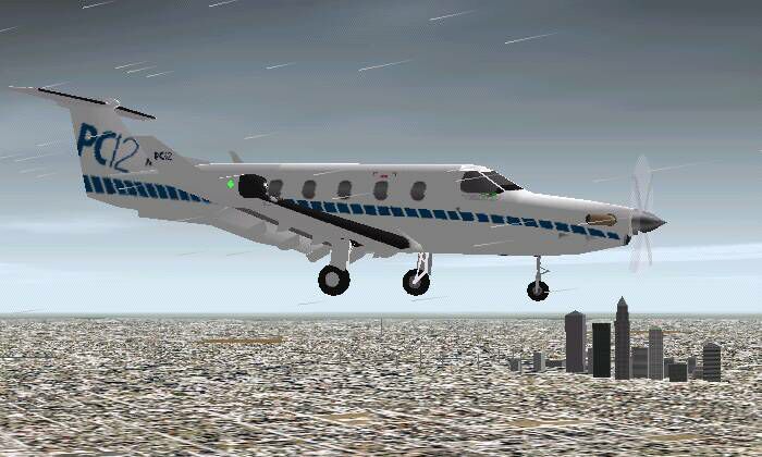
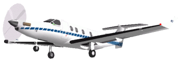
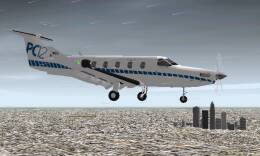 New
Aircraft, New Livery New
Aircraft, New Livery
(Jan. 8th VD/Apr. 18th RD)
CHARLOTTE,
North Carolina, USA: I'm
not giving away the Pilatus PC-12, but I've switched to Marcel
Ritzema's new version of the plane, with full moving parts and a new
livery. This paint scheme is used by Pilatus to promote the plane in the
US. It's a bit more difficult to fly, but I have a few thousand miles
ahead to get acquainted with it. ENLARGE |
The Shortest
Runway
(Jan. 9th VD/Apr. 21st RD)
ELKIN, North
Carolina, USA:
The
landing in Royals (# 277) was one of the most difficult I will
have in the whole trip. The runway is only 700 feet long and I guess I
will not find a shorter one in the rest of the flight. The
Pilatus PC-12 can roll to a stop in less than that distance but you have
to approach the runway at the minimum airspeed and if you can't touch down
in the first few feet of the runway, you have to throttle up and go around. |
Getting the Numbers Right
(Apr. 29th RD) BUENOS
AIRES, ARGENTINA: I've
found (and corrected) an error I made in the Excel spreadsheet I use for all the stats of
the flight. If you were paying attention to the Stats
section, you saw the
number for consumption average (5.5-5.7 gallons per nautical mile) was
extremely high, about 50% more than what a B737 consumes in cruise. The correct
number is 1.63 Gal/Nm. The speed average (74.01 kt) was also
wrong, but here the number didn't vary significantly.The appropriate number is 70.25
kt. |
 Landmarks Landmarks
(Jan. 9th VD/Apr. 26th-29th
RD)
BRYSON CITY,
North Carolina, USA: On these last
few airports in
North Carolina,
I reached several landmarks. 300 airports
visited (Hendersonville), 30.000
pounds of fuel used (Jackson County, # 306) and 40 flight hours (Sossamon Field,
# 308).
ENLARGE
|
 North Carolina Done! (At Last) North Carolina Done! (At Last)
(Jan
10th. VD/Apr. 30th RD) HAYESVILLE, North
Carolina, USA: After
several months of flights, I've landed at Tusquitee Landing, the last
airport in North Carolina. The final numbers for the State: 310 airports,
40:26 flight hours, 2854.5 nautical miles.See details in the Stats
section. |

 |
NOTAM:
Those Signs Again
(Jan 10th. VD/May 9th RD) CHESTER,
South Carolina, USA: I
know those yellow and orange signs are no more than a visual approach aid
but, for me, they are also a sign of trouble to come. Every time I
see them, my airplane crashes mysteriously (see Notam
for Johnson Airfield). In this
case (Chester Municipal, #354) the accident point is the
intersection between runway 05-23 and the taxiway parallel to runway 17-35
(Map).You can still use the taxiway in the way to Rwy 35, but remember to
turn left when you reach Rwy 05-23, instead of crossing
it. Conversely, you can use Rwy 05-23, but only from the intersection
with 17-35 to the NE. |
Great Offer: Two
for One
 (Jan
11th. VD/May 15th. RD)
ST MATTHEWS, South Carolina, USA: It's
the same as in North Carolina, two airports so close one another that it
would seem it's only one airport with two runways (see News
Archive). It took 7 minutes to fly between Alan's, SC07
(#387) and Do-Little Field, SC90 (#388), separated just 0.1 mile.
Speed average: 0.86 kt. ENLARGE (Jan
11th. VD/May 15th. RD)
ST MATTHEWS, South Carolina, USA: It's
the same as in North Carolina, two airports so close one another that it
would seem it's only one airport with two runways (see News
Archive). It took 7 minutes to fly between Alan's, SC07
(#387) and Do-Little Field, SC90 (#388), separated just 0.1 mile.
Speed average: 0.86 kt. ENLARGE |
South
Carolina...
is History
(Jan. 13th VD/May 28th RD) NORTH
MYRTLE BEACH, South Carolina, USA: A
few minutes past 10 am, I landed at Grand Strand, KCRE (#463), the
last airport in South Carolina. I will take a short while to check the
route and will depart for the Bermuda Islands, in what will be my
first flight over the ocean. Final numbers for South Carolina: 153
airports, 1,604 nautical miles, 18:51 flight hours. Details in Stats
section. Over the next few days I will add (belatedly) some Aircraft
related to this State. |
BACK TO MAIN PAGE
NEWS
ARCHIVE Page 3
NEWS FROM THE BEGINNING
|


 Sign
My Guestbook
Sign
My Guestbook