GREET ME
at the
AIRPORT

Click Here
When I finally arrive
in your city, I hope you'll be waiting for me on the tarmac.
You only have to say where you live.
Send me an E-mail
or sign the
Guestbook
|
Do
you
Believe
I'm
crazy?
That
I Never
Gonna
Do It?
Give your
opinion by E-mail
or in the
Guestbook
|
|
|
NEWS ARCHIVE Page
4
NOTE:
Unlike the Main Page, where latest news appear at the top, here you will
find the news sorted chronologically, from top to bottom
 100 Hours in
Cairo 100 Hours in
Cairo
(Jan. 20th VD/July 26th RD) CAIRO, Georgia, USA:
Don't get
confused by this title. This expedition is not as fast as you think. I'm
not in Egypt yet and I'm not delayed by the weather. Cairo is a town in
Georgia and this is a new mark in my flight. When I was approaching Cairo-Grady
County airport (70J, # 776), I reached the first 100 flight hours. |
What's
This?
(Jan. 18th VD/July 21st RD) DAWSON, Georgia, USA:This
strange building is a few miles Northwest of Dawson's Hayes airport
(9GA3, # 719). It is about 1,100 feet
tall. Remember those TV commercials with a pickup truck at the top of a
butte? Well, I landed a Boeing 777 at the summit just to demonstrate its diameter.
Don't try this at home!!! Do you know what is it? If
you have any clues, send me an e-mail. |
  |
 End
of Georgia End
of Georgia
Next Stage: Florida
(Jan. 20th VD/July 26th RD) CEDAR
SPRINGS, Georgia, USA: Georgia
Pacific (00J, #781) is the last airport in Georgia. The final numbers
for this State: 317 airports and 4,465.9 nautical miles in 41:26
flight hours. Now I'm going south to Florida's 518 airports. |
Which Side of the
Border?
(Jan. 20th VD/July 28-30th
RD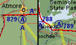 ) WALNUT
HILL, Florida, USA: Mike's
AG Air airport (49FL, #829) is
less than one mile south of the Alabama state line (left map). One mile to
the South, there is an unnumbered airfield. This airfield, Parker
Flying Service (AL64) is clearly in Florida, but belongs to Alabama
and will be visited when I go to that State. There is also the opposite case:
the town of Chattahoochee (right map) is undoubtedly in Florida.
However, its airport (53J, #789) is one mile into Georgia, though it's
listed in Florida. ) WALNUT
HILL, Florida, USA: Mike's
AG Air airport (49FL, #829) is
less than one mile south of the Alabama state line (left map). One mile to
the South, there is an unnumbered airfield. This airfield, Parker
Flying Service (AL64) is clearly in Florida, but belongs to Alabama
and will be visited when I go to that State. There is also the opposite case:
the town of Chattahoochee (right map) is undoubtedly in Florida.
However, its airport (53J, #789) is one mile into Georgia, though it's
listed in Florida. |
New Maps Section
(August 11th RD) I'm
redesigning the Maps and Routes section to make it clearer and
easier to view. Now you can scroll a long list of airports without losing
sight of the respective map. A map of the Country or State is always on
screen, showing the relative position of each map. You can navigate
between maps clicking on the edges to go to a contiguous map. An image of
each zone, when there is one, is also displayed, integrating the Photos
section with the maps. This section is not finished yet, and could contain
some errors. You can already see all of Georgia and about half of Florida.
North and South Carolina and Bermuda will be added soon. Your browser must
support frames and Javascript. Click
here to see it. |
10,000 Miles!
(Jan. 22nd VD/Aug. 24th RD ) GLEN
ST MARY, Florida, USA: Though
this is only a short part in this long expedition, today I've reached an
important landmark in my flight around the world. Landing in Cuyler
Field (FD27, #929), a short airfield west of Jacksonville, I
logged the first 10,000 nautical miles (11,516.5 statute miles, 18,530
kilometers). This is comparable to New York-Perth, Paris-Auckland
or Buenos Aires-Tokyo flights. However, I'm only 472 miles from my
starting point, Kitty Hawk, North Carolina. ) GLEN
ST MARY, Florida, USA: Though
this is only a short part in this long expedition, today I've reached an
important landmark in my flight around the world. Landing in Cuyler
Field (FD27, #929), a short airfield west of Jacksonville, I
logged the first 10,000 nautical miles (11,516.5 statute miles, 18,530
kilometers). This is comparable to New York-Perth, Paris-Auckland
or Buenos Aires-Tokyo flights. However, I'm only 472 miles from my
starting point, Kitty Hawk, North Carolina. |
New Records
(Jan. 22nd VD/Sep. 7th RD) ORANGE
SPRINGS, Florida, USA: 85th
Avenue Airstrip (FD02, #974) is the last airport of the 20th day of flights.
Today I landed in 69 airports, breaking my previous mark of 65
for a single day.
At noon, during the flight to Mayport NS, I had
reached the first 50,000 liters of fuel burned. |
BACK TO MAIN PAGE
NEWS
ARCHIVE Page 3
NEWS FROM THE BEGINNING
|


 Sign
My Guestbook
Sign
My Guestbook